Low Moor Allotments Association
Home | Getting
Started | Problems Page |
Pictures | Where are we? | Useful Links | Meetings | Archives | Fruit Tree Register | Allotment Shop | Site Plan
Low Moor Allotments Association |
|
|
Home | Getting
Started | Problems Page |
Pictures | Where are we? | Useful Links | Meetings | Archives | Fruit Tree Register | Allotment Shop | Site Plan |
|
|
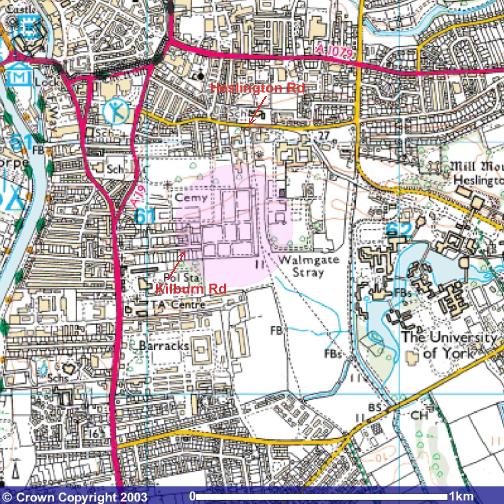
Where are we?Here's a map showing where we are in York. It shows the cemetery and Walmgate Stray (public common land) - the Low Moor Allotments are between the two! Access is generally from Heslington Rd (metal gate at top of hill) or Kilburn Rd (car park at end of road).Image produced from the Ordnance Survey Get-a-map service. Image reproduced with kind permission of Ordnance Survey and Ordnance Survey of Northern Ireland. Below find some interesting information on the surrounding area, including the history of Low Moor before allotments. The surrounding area to Low Moor Allotments, including
The Retreat, was designated a Conservation Area by the Council in 1975.
|
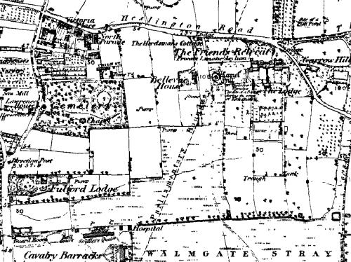
The Retreat / Heslington RoadConservation Area No. 8 (22.0 ha)IntroductionThe land area of the Retreat and Heslington Road Conservation Area was originally outside the City of York and part of Fulford. It occupies the highest ground south of the City including Lamel Hill and Garrow Hill and commands views northwards across the City of York and southwards over Walmgate Stray and Low Moor to the village of Fulford. It is located within the City of York Green Belt. The conservation area was designated in 1975.HistoryLamel Hill is a large mound raised during the Civil War. It formed part of the Civil War works which encircled York. The area around the mound includes an extensive late Roman or Anglian cemetery; because of this Lamel Hill is a scheduled ancient monument and the area has been designated an Area of Archaeological Importance. In 1793, York Quakers decided to purchase 2 closes of land in Fulford to create a new hospital for the mentally ill. Their aim was to provide humane treatment, in airy surroundings with access to gardens and farm animals. They followed the advice of the prison reformer John Howard and their architect Bevan in choosing rising ground with a plentiful supply of water. To oversee the details of the building works they engaged the local architect Peter Atkinson. The grounds of the Retreat encompass Lamel Hill and a Quaker burial ground. |
|
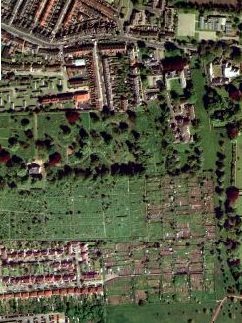 |
The allotments next to the somewhat larger (24 acre) site of York Cemetery (to the left and above of the Low Moor site). To the right, the thin strip of Walmgate Stray passes. At the bottom left corner, Kilburn Rd. can be seen leading onto our car park. At the top of the picture, Heslington Rd snakes down from the University. Joining onto this in the centre, the houses of Belle Vue St. and Belle Vue Terrace, separated by their gardens. Apollo St. and the sheltered housing is visible in the top right corner. The gardens of the Retreat are just out of the picture on the right. |
Important buildingsThe Retreat, established in 1796, and extended in 1799, 1803 and later, is the focal point of the Conservation Area.CharacterThe major element which gives this Conservation Area its distinct character, is an institutional use - The Retreat - set in parkland surrounded by obscuring walls but with views out. The Retreat grounds were enclosed with high walls to keep the patients safe inside the garden areas. These were laid out with numerous ornamental trees and shrubs and with hedges in a series of gardens and parkland. In the 1850's further areas were purchased and the hospital extended whilst still retaining its parkland setting. The open character of the Conservation Area extends west to York Cemetery, south to Walmgate Stray and east to the landscaped campus of the University. The Conservation Area also includes, in contrast, the pleasant Victorian suburban houses on Belle Vue Terrace some of which are listed. The main elements of the character and appearance of the area are:
|
|
|
Home | Getting
Started | Problems Page |
Pictures | Where are we? | Useful Links | Meetings | Archives | Fruit Tree Register | Allotment Shop | Site Plan | |
| Page last updated: 19 February, 2009 | |